Contact Us | Connect:


| Record Series: | Maps, Plats and Aerial Photographs |
|---|---|
| Collection: | General Map Collection, 1851-2005 |
| County: | Statewide |
| Item Number: | AR-270-B-000009 |
|---|---|
| Creator: | |
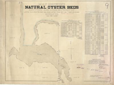
| Title: | Map showing natural oyster beds |
| Date: | 1894 |
| Extent: | 1 map ; 22.5 x 30 in. |
| Scope And Content: | Map shows natural oyster beds in Kitsap County. |
| Notes: | Title continues, "abutting and lying in front of lots 1. 3. 4. 5. 6. 7. 8. sec 35, and lots 7.8. sec 36. T 26 N, R1 E.W.M. / Kitsap Co."Traverse tables indicate the area of tracts 1 and 2. Certified by the Board of Shore and Tide Land Appraisers of Kitsap County, Washington. Certificate signed by John T. Mitchell, J.E. Baker, and R.D. Herrington. "FILED in OFFICE of Board of State Land Commissioners. / OCT 11 1894 / E. D. [Cowan] / SECRETARY."--stamped at lower right."35.36. 26.1.E. / 89."--in bottom right corner. "Vacated Jan. 13, 1930."--written in red below title. Scale 1:2,400. |
| Access Restrictions: | None. |
| Genre: | Maps |
| Index Terms: | |
| Publisher: |
| Source: | /Record/View/c657722816f99b036f2610c790ad1455 |
|---|
| Date Added | Name | Comment |
|---|